
Ditches of Sandy Gulch
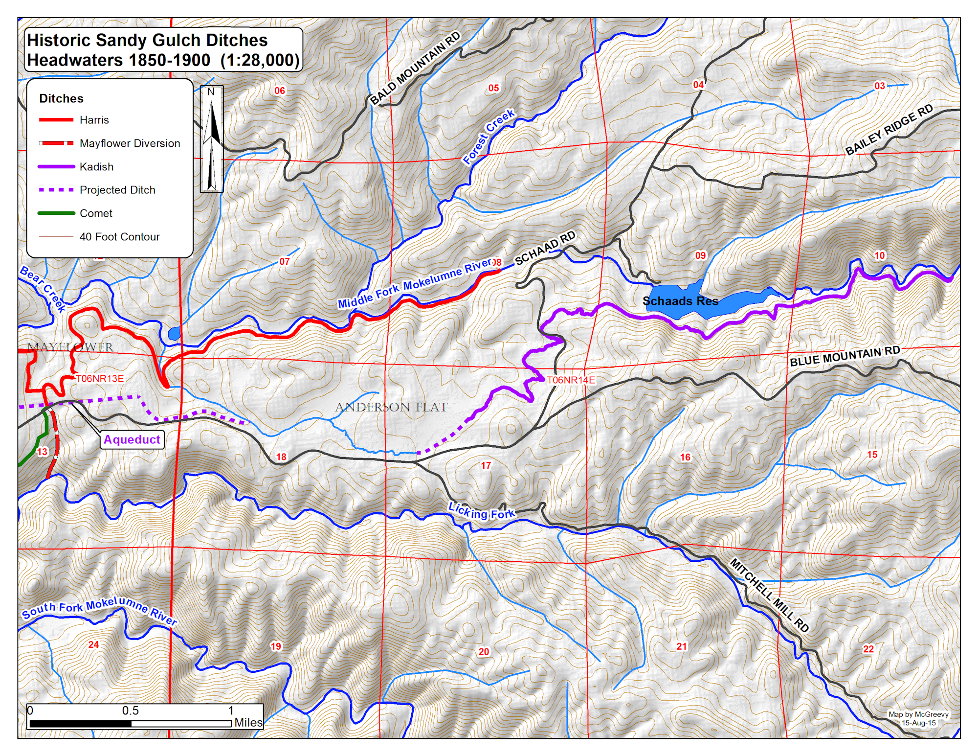
Both placer and lode mining depended on a supply of water. During the initial years of the gold rush, placer claims followed the streams while ore mills were located at the bottom of steep canyons on the rivers. To extend mining activities beyond the seasonal limits of the winter and spring runoffs, and to locate mills at convenient locations near mines, two primary ditches were constructed to divert water from the Middle Fork of the Mokelumne River and convey it to Sandy Gulch: the Harris Ditch and the Kadish Ditch.
While historic journals and county records describe the Sandy Gulch water system, the location of divergence points on the Middle Fork Mokelumne and ditch alignments were rarely plotted on maps. A survey of a dozen maps from the Stanislaus National Forest and the US Geological Survey plotted between 1858 and 2001 ignored the Sandy Gulch water system. Exceptions are found in the 1858-1870 GLO map that depicts the Kadish Reservoir along with the location of the Kadish vineyard and local road system (Figure 6). An important map of the Mokelumne and Campo Seco Canal and Mining Co.(ca. 1900) plots the Harris Ditch in its entirety, but excludes the Kadish and Littlefield Ditches.
Starting in 2005, numerous explorations were made to locate the ditches described in the literature. As ditch segments were found, they were recorded by GPS and mapped using ESRI software. Over their 150 year history, the wood trestles, flumes and gate valves have rotted away and many ditch segments were destroyed by road construction, agriculture, building, logging and mining -- the loss of these features accounts for many of the gaps in ditch continuity. Other gaps reflect inaccessible private property within the settled areas of Wilseyville and Sandy Gulch.
Harris Ditch. By 1853, miners constructed a ditch that diverted water from the Middle Fork Mokelumne River, 1.7 miles downstream from Schaad’s Road at an elevation of 2,760 feet and conveyed it to Sandy Gulch. The ditch water ran for eight miles across the north facing slope of the Middle Fork Mokelumne River Canyon to the NE corner of Sandy Gulch. The Bunker Hill Canal and Mining Company was created in 1853 to manage the ditch (Calaveras County 1853). By 1856, Allen H. Harris acquired the interests of various owners and was assessed for the ditch in that year (J.A. Smith unk,). This ditch became known as the Harris Ditch, but was also called the Bunker Hill Canal, Sandy Gulch Ditch, and Mayflower Ditch.
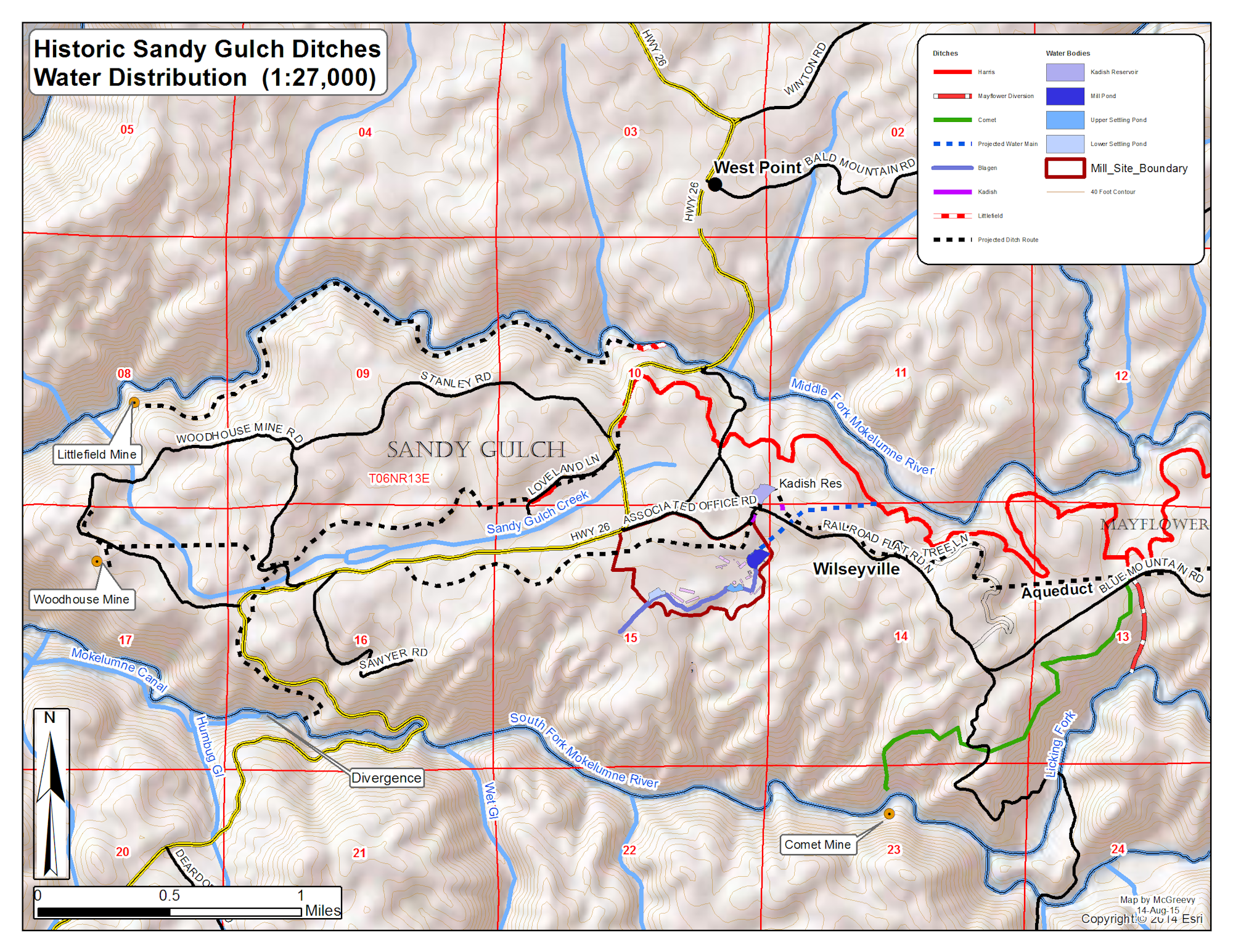
The Harris Ditch entered Sandy Gulch where current Hwy 26 cuts through the hill just north of Stanley Road. The highway destroyed this segment of the ditch, although two cross sections remain on the eastern surface of the cut near the top of the hill. The water flowed south down the hill and powered the lumber and quartz mills operated by Allen Harris near the intersection of Loveland Lane and the highway. After passing through the mill, the water continued west and ditch segments can be seen today on the south side of current Loveland Lane beyond the Cemetery. The ditch then turns north, crossing Loveland Lane and proceeds across private property in a westerly direction (Carlins 2005), paralleling Sandy Gulch Creek on the north side at a higher elevation. The ditch must have been flumed over Sandy Gulch to reach and power the Woodhouse shaft, hydraulics and the Underwood Quartz Mill built in 1875 (J.A. Smith unk; K Smith 1996). Along the way, the Harris Ditch irrigated fields on the Mayflower Ranch and Sandy Gulch. In later years, the Harris Ditch was diverted into the Mokelumne Canal, Comet Ditch and the Blagen Ditch that are described below.
In 1877 the Harris Ditch was sold to the Mokelumne Hill Canal and Campo Seco Mining Company and its water diverted south down “Rose Gulch” (somewhere near the current Highway 26 grade) into the South Fork Mokelumne River -- just upstream from the Mokelumne Hill Canal diversion dam -- and conveyed to Mokelumne Hill and beyond (J.A. Smith unk; 1959). Some 20 years later the Company moved the Harris Ditch diversion point 3.5 miles east to the Mayflower Ranch where they piped the water under Blue Mountain Road, let it flow freely down a natural drainage to the Licking Fork, into the South Fork Mokelumne and the Mokelumne Canal at the aforementioned diversion dam (Figure 9). Eventually, the Harris Ditch segment from Mayflower to Sandy Gulch was closed. Without water for irrigation, agriculture in Sandy Gulch declined (J.A. Smith 1961).
Comet Ditch. Sometime between 1880 and 1914, the Comet ditch was constructed from Mayflower to the current Strange property (T6N R13E, Sec14) to power the Comet mill on the South Fork Mokelumne River. Water from the Harris Ditch was piped under Blue Mountain Road and conveyed westerly along the south facing slopes of the Licking Fork and South Fork Mokelumne for 1.7 miles where it was turned into a penstock. The penstock descended ~440 feet to the South Fork Mokelumne, crossed the river suspended from a cable, and drove Pelton wheels powering the Comet mill (Figure 8; Mechling 2005). Today, the Comet ditch is largely intact, a few pieces of the penstock lie on the steep slope of the Strange property, and the cable still hangs above the river (Leach-Palm 2006).
The importance of the Mayflower Diversion to the Moke Canal Company must have declined over the first half of the 1900s. While the Moke Canal Company increased its water supply by tapping the Calaveras River, the demand for water probably declined due to mine closures. In 1942, the Associated Lumber and Box Company initiated construction of the Associated Lumber and Box Co. sawmill in Sailor Gulch, just south of Sandy Gulch, and re-opened the abandoned segment of the Harris Ditch from Mayflower to Wilseyville then owned by the Calaveras Public Utility District (CPUD) (Anonymous 1999). Since the ditch ran in the Mokelumne Canyon on the east side of the current Wilseyville Camp, the water was pumped ~60 feet uphill to a reservoir on the hilltop to the west. From here it was piped by gravity to the mill facilities throughout Sailor Gulch for domestic use and to fill the 47 acre-foot mill pond and generate steam power.
Initially, wastewater from the mill was released into a drainage that crossed the neighboring property on the south owned by Burt Howe. Around 1945, Howe obtained a court order forcing the mill to stop polluting his well. Faced with a mill closure, manager Howard Blagen surveyed a bypass, mustered the company’s earth moving equipment and worked 24 hours a day for 10 days to excavate two settling ponds and a ditch measuring 0.7 miles that cut deeply through a ridge onto government land on the west. We call this impressive wastewater system the Blagen Ditch.
With the closure of the mill in 1969, the company’s 28 residences, known as the Wilseyville Camp, and the commissary were sold to individual families. These folks maintained the Harris Ditch segment from Mayflower and received their domestic water as in lieu customers of CPUD (Anonymous 1999). In 1974, the Calaveras County Water District (CCWD) annexed the Camp into its West Point Service Area and supplied it with domestic and waste-water services starting in 1976. The CCWD soon determined that the ditch was too expensive to maintain as it was tapped by a number of illegal users and exposed to leachate from stand-alone septic systems (Mother Lode Engineering, Inc. 1974). In 1976, the CCWD piped water from their West Point Water Treatment Plant to the Camp and the section of the Harris Ditch from Mayflower to the Wilseyville was permanently closed. The segment of the ditch from its intake below Schaad’s Reservoir to the diversion at Mayflower was closed around 1997 due to the lack of maintenance and the unacceptable loss of water (Haley 2005).
Kadish Ditch. The Kadish Ditch also took water from the Middle Fork Mokelumne River and conveyed it to Sandy Gulch. It was constructed in two stages. In 1856, W.T Harris and others claimed and surveyed a ditch to divert water from the Middle Fork Mokelumne River -- about 2.5 miles above Schaads Road at an elevation of 3,120 feet -- and convey it to Anderson Flat, a distance of 3.7 miles (Calaveras County 1856) for mining purposes. The ditch, known as the Anderson Flat Ditch, was operational in 1858 when the owners became indebted to Manuel Kadish who operated a store in Sandy Gulch. Kadish secured judgement against the owners and acquired the deed to the ditch in a sheriff’s sale on September 25, 1858 (J.A. Smith unk; Calaveras County 1858).
Kadish extended the ditch in a westerly direction to Mayflower and on to the Kadish Reservoir at the head of Sailor Gulch. From the reservoir, the ditch entered southeast Sandy Gulch about 80 feet above the Harris Ditch, providing water to the higher fields on the east side of the settlement. It also flowed westerly along the current route of Associated Office Road and Hwy 26 to Mrs. Kadish’s Vineyard (Figure 6; Timon 1858; J.A. Smith unk. 1961).
While the original Anderson Flat Ditch is well delineated, signs of the Kadish extension to the west between Anderson Flat and Sailor Gulch were not found. Historical records indicate that that Kadish water was conveyed over the Mayflower Ranch in a long, high flume called the Kadish aqueduct (J.A. Smith 1961; Calaveras County 1869). Ailene Haley, who was born in 1929 and raised on the Mayflower Ranch, saw a photograph of the flume that crossed Ray Steven’s property (location unknown) when she was a little girl. Her husband, Lee, claimed that a segment of the Kadish ditch ran above the home of Joe Weatherby, his son, (located at 38˚ 22.73’ -120˚ 29.65’, Elevation 2740 feet) but that it was covered up (Haley 2005). The alignment of the Kadish ditch from Mayflower to the Kadish reservoir, elevation 2720 feet, is elusive. Faced with the extensive excavations in the area caused by the Associated Lumber and Box Company, the Lynn Acres Subdivision, and county roads, it is unlikely that additional segments of the Kadish Ditch will be found.
Two short segments of Kadish ditch have been located near the Kadish reservoir. The segment south of the reservoir probably conveyed water passing through current Wilseyville to the reservoir (Cook and Costello 2006). The second segment was found 275 feet southwest of the Kadish dam on the east side of Associated Office Road just east of its intersection with Rail Road Flat Road. This segment probably conveyed water westerly from the reservoir to the Kadish vineyard.
On August 1, 1863, Manuel Kadish sold his ditch system to A. McGregor (Calaveras County 1863). In drought years, there was not enough water in the Middle Fork of the Mokelumne River to supply both the Harris and Kadish ditches and the latter, with its junior water right, was eventually closed (J.A. Smith 1961). Henry L. Read and associates formed the Blue Mountain Water Company in 1896 and claimed 10,000 inches of water taken at the Kadish diversion dam on the Middle Fork Mokelumne as well as the old Kadish ditch. It is unclear if the ditch was actually operational at this time.
Littlefield Ditch. The Littlefield Ditch ran along the south bank of the Middle Fork Mokelumne River and powered the Littlefield Quartz Mill in Lower Sandy Gulch, powering an arrastra and a ten-stamp mill (Mulford 1858; Calaveras County Deed Book E, p. 283, 1860). The point of divergence has been located on the south side of the river about 390 yards below Taylor Bridge on Hwy 26 where a segment of ditch measuring 77 yards in length was located and mapped. Exploration westerly for the ditch was impossible due to ground disturbance and brush. Clark (1962) placed the Littlefield Mine just south of the Middle Fork Mokelumne River (SE corner of Sec 8, T6N R13E) although its exact location is unknown. Any or all of the six adits identified in this area could be associated with Littlefield. To reach this location, the Littlefield Ditch would have been about three miles long.
By Patrick B. McGreevy, 2015
Article from: Costello, Julia G., and Patrick B McGreevy, 2015. Cultural Resources Survey and Evaluation for the Woody Biomass-Fired Combined Heat and Power Project, Wilseyville, CA.. Prepared by Foothill Resources, Ltd., Mokelumne Hill, CA; prepared for Calaveras Healthy Impacts Products Solutions Group, West Point, CA.
References
Anonymous
1999 The History of the Calaveras Public Utility District, 68pp.
Job Underway Near County Seat, November 25, 1937.
Blagen, H, 2007. The Howard Blagen Story. Available at http://sierraloggingmuseum.org/our-community/the-blagen-story/.
Calaveras County
1853 Agreements Vol A IV, September 20, 1853, pp 1-2. On file at the Calaveras County Archives, San Andreas, California.
1858 Deeds Book D, p 2. On file at the Calaveras County Archives, San Andreas, California.
1860 Deeds Book E, p 283. On file at the Calaveras County Archives, San Andreas, California.
Clark, William B. and Philip A. Lydon, 1962. Mines and Mineral Resources of Calaveras County, California, County Report Number Two. California Division of Mines and Geology.
Carlins, Randy, 2005. Interview with Randy Carlins. On file at the Calaveras County Archives, San Andreas, California.
Haley, L. and A. Haley, 2005. Interview with Leland and Ailene Haley. On file at the Calaveras County Archives, San Andreas, California.
McGreevy, Patrick B., 2005d Interview with WilliamDoughtery. On file at the Calaveras County Historical Society, San Andreas, California.
McGreevy, Patrick B., and Lloyd D. Ames
2005 Interview with Leland and Ailene Haley. On file at the Calaveras County Historical Society, San Andreas, California.
Mechling, J., 2005. Interview with Jess Mechling by Patrick B. McGreevy. On file at the Calaveras County Archives, San Andreas, California.
Mother Lode Engineering, Inc.. 1974 Wilseyville Assessment Report Prepared for Calaveras County Water District. On file at the Calaveras County Historical Society.
Mulford, D.L., 1858 Assignee’s Sale, Estate of Lambert Littlefield. San Andreas Independent, November 27, 1858.
Smith, J. A., n.d. The Old Sandy Gulch Ditch. On file in K. Smith’s “West Point History Project” at the Calaveras County Archives, San Andreas, California.
1959 The Mokelumne Hill Ditch. Las Calaveras 8(1):1-2.
1961 Sandy Gulch. Las Calaveras 10(4):3.
Smith , K (ed), 1996. Smith West Point Historical Project. On file at the Calaveras County Historical Society.
Surveyor-General of the State of California, 1855 Annual Report of the Surveyor-General of the State of California, Appendix F, 1. Report of WM. Patton, of Calaveras County, Civil Engineer. Pp 322-328.
Timon, 1858. From West Point. San Andreas Independent, October 28, 1858.