
Highway 26: Mokelumne Hill to West Point
The steep canyons formed by the branches of the Mokelumne River presented formidable obstacles to transportation. Development of a route east from Mokelumne Hill was largely dictated by the availability of suitable points to cross the seasonally roaring water courses located at the bottom of steep canyons. While the general location of the river crossings has remained the same for 150 years, there have been a succession of bridges and roads driven by the needs to import mining supplies and heavy equipment during the gold rush and to export logs and lumber after the Depression. The early trails for pedestrians and mule trains evolved into narrow dirt roads characterized by minimal cuts and fills, sharp curves, and steep grades that supported stages coaches pulled with teams of two and four horses and pairs of tandem freight wagons towed by teams of 20 mules. Gradually the roads improved and in the early 1900s it took only half a day for the stage to travel from Mokelumne Hill to West Point via Rail Road Flat (Gray n.d.). The first car arrived in West Point in 1905 (K. Smith 1996).
Major road improvements occurred at the end of the Great Depression as New Deal projects focused on the economic development of northeast Calaveras County, particularly the lumber industry. During this period, new segments of road were constructed to minimize sharp curves and steep grades while the old segments were realigned, re-graded, widened, and surfaced with oil and asphalt. By the end of the 1940s, the trip time from Mokelumne Hill to West Point was reduced to a half hour.
Serious road improvements began in 1855-6 when George A. Conrad built a toll bridge across the South Fork of the Mokelumne River at the crossing of the trail leading from Mokelumne Hill to West Point — this original location was about 200 yards west of the current cement bridge. Conrad also improved the steep approaches to the bridge to support stage coaches and freight wagons (Calaveras County Board of Supervisor Minutes, p. 43-44, 1855; Calaveras County Deed Book B, p. 1015, 1858; Calaveras County Deed Book C, p. 328-329, 1858; J.A. Smith 1954a). Conrad’s Bridge washed out in December, 1861; the northern and southern approaches and abutments can still be seen today (McGreevy 2005e field notes).
Conrad’s Bridge was replaced the following April by M.G. Sawyer who constructed a wire suspension bridge that was 150 feet long and 53 feet above the water, crossing the river about 150 yards west of the current bridge. Sawyer also realigned both approaches. The Sawyer Bridge operated for 34 years before it was declared unsafe by the County Board of Supervisors and demolished in 1898 (Calaveras Chronicle 1862a and 1862b; J.A. Smith 1954a). There is no sign of this bridge today. During these first decades, it probably took the better part of a day to travel by stage coach from Mokelumne Hill to West Point via Sawyer’s Bridge as the stage departed the Hill on Monday, Wednesday and Friday and returned the following day ( Calaveras Chronicle 1862c).
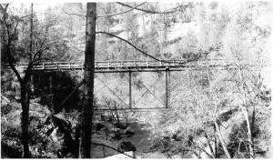
In 1898, the Cotton Brothers built a new steel bridge at the same point where Sawyers had been. The Cottons’ bridge had a span of 140 feet and a 16-foot wide wood deck (Calaveras Board of Supervisor Minutes 1896a and 1896b). The current cement bridge with its asphalt surface was put in service in 1938 and the Cottons’ bridge was removed. Today, the rock abutments and approaching roads to the Cotton Bridge can be found on both sides of the South Fork.
Segments of the pre-1930 roads can still be found on the descent down the southern slope of the canyon from Glencoe to the river where they crisscross the current Highway 26. In contrast, the ascent up the northern slope does not follow Highway 26, but travels directly up the steep grade using two switchbacks before connecting with Sawyer Road (See GLO map). As the latter approaches the southern edge of the ridge, it turns east onto Main Street, Sandy Gulch, and follows a course close to the current Highway 26 for a mile to the intersection with the current Sandy Gulch Road.
On the eastern side of Sandy Gulch, the Mokelumne Hill-West Point Road also changed with time. The original road shown on the GLO Map dated 1858-1870 roughly follows the route of the current Highway 26 turning sharply to the north at the intersection of current Sandy Gulch Road, going past the Harris barn (alias Crosby barn) and turning north east before descending to the Middle Fork of the Mokelumne River. By 1894 the leg between the Harris Barn and the Middle Fork of the Mokelumne River was probably reduced to a pedestrian trail. Instead, Main Street continued east over the current Sandy Gulch Road, connected with Railroad Flat Road at an intersection called the Sign Boards (current Lambert’s Corner) and then descended north to the river. In addition, a new road appeared that led from the Harris Ranch to the Sign Boards and this dirt road is still visible today.
This configuration remained until the Mokelumne Hill–West Point Road was upgraded in ca. 1942 and the original link between the Harris Barn and the Middle Fork Bridge was re-graded and returned to service (Calaveras Prospect 1942). Finally, around 2000, the Middle Fork Bridge was replaced at the same point with a new bridge designed to withstand earthquakes and the approaches were re-aligned.
By Patrick B. McGreevy, Glencoe, 2007
References
Calaveras Chronicle
1862a New Suspension Bridge, June 21, 1862.
1862b Stage Line Resumed, June 21, 1862.
1862c Editor Chronicle, June 21, 1862.
Calaveras Prospect
1942 Large New Lumber Mill to be Constructed in West Point District, March 14,
1969 Lumber Mill at Wilseyville Stilled. March 15, 1969.
Gray, Joseph
n.d. Letter’s. Calaveras Prospect. On file at the Calaveras County Historical Society, San Andreas, California. (Find letter and article in Calaveras Prospect around July 28 in or around the year that Artie Wilson died which was probably after 1981)
McGreevy, Patrick B.
2005 e Field Notes: Bridges over the South Fork of the Mokelumne River. On file at the Calaveras County Historical Society, San Andreas, California.
Smith, J. A.
1954a The South Fork Bridges between Glencoe and Sandy Gulch. Las Calaveras 5(2):3.
Smith, K (ed)
1996 West Point Historical Project. On file at the Calaveras County Historical Society.