
Mining in the Lake Tulloch Area
The early history of stretch of the Stanislaus River around present-day Tulloch Reservoir is ephemeral at best, but the locale appears to have been first worked during the Gold Rush at Spanish Bar, Six Mile Bar, Two Mile Bar, and others, as well as on Littlejohns Creek, Ramsey Gulch, Scorpion Gulch, and other associated drainages. During the early years placer mining activities along the Stanislaus River were carried out by numerous individual miners using simple gold pans, bateas, sluice boxes, and rockers. Later, when the free gold had been picked up, miners formed companies who built Long Toms, elaborate wingdams, flutter wheels, and used other means to turn the rivers and pluck the nuggets from the stream beds.
Numerous drift mines were also dug into the Tertiary gravels located beneath Table Mountain. According to an account published in 1856:
"The number of miners interested in Tunnelling and prospecting this mountain, in Calaveras, Tuolumne and San Joaquin Counties, cannot be less than three thousand; quite a number have 'cut the lead' and are realizing fortunes; others who are but partially in, are equally as sanguine of success." (Heckendorn and Wilson 1856).
Placer mining continued in the Scorpion Gulch/Ramsey Flat Area at least through the early 1870s, as numerous miners, primarily Chinese, were listed by the census enumerator in 1860 and 1870. The men in the Spicer and Moulton families, as well as in others, noted themselves as miners and stockraisers in those years, and in 1880 as miners, suggesting that they were continuing to mine their land, although also carrying on their stock raising activities at the same time. By 1900 all were noted as farmers, the gold evidently having eventually completely played out (U.S. Federal Census 1860, 1870, 1880, 1900).
Hard Rock Mining
Scorpion Gulch, located on the Rancho del Rio Estanislao grant, was the site of the most important mining activity in this area. Gold mining at Scorpion Gulch commenced in the early 1850s and appeared to be moderately successful. A newspaper article in 1858 described the activity:
"In and about Scorpion gulch, are many good quartz claims—many of whose richness and value their owner took occasion to call my attention to, and expatiate at some considerable length, upon future prospects and probabilities. If they had but considered that their auditor came from Angels—this camp of magnificent proportions—they would possibly have had less faith in the success of their attempts to excite my credulity." (San Andreas Independent, April 10, 1858).
By 1860, A.S. Moyer had erected a house and store, as well as a “sleeping apartment,” at Scorpion Gulch (Calaveras County Assessment Rolls 1860). In 1863 W.G. Taylor was assessed for a house and garden at the same location (Calaveras County Assessment Rolls 1863). A few years later Moyer moved his operations to the burgeoning town of Copperopolis and Scorpion Gulch was apparently abandoned.
Alto Mine
In the latter quarter of the nineteenth century, the Scorpion Gulch area was to boom again with George Blazer’s opening of the Alto Mine (sometimes erroneously called the Alta), the only significant hard rock mine in the region. Reputedly examined by George Hearst in the early 1860s, the lode was substantiated in 1886 by George and his son Tom. The Blazers operated on a limited scale, doing most of the work by simple hand labor. They dug a large glory hole, but the mineralized slate which was laced with numerous quartz stringers didn’t produce as anticipated (Criswell 1972).
In 1895 George Fitch and his son-in-law Oliver Britt obtained an option or lease from Captain Wright, the owner of the Grant, to prospect and mine. With George Blazer, the miner and rancher well acquainted with the area, they prospected on Ramsey Flat and in Scorpion Gulch and began to develop the Alto for mining (Las Calaveras, Vol. XXXI, No. :6-7).
Soon thereafter Tom Lane, the grandson of Major Lane of Knights Ferry, became associated with Fitch and Britt and a 10-stamp mill was erected on the property by the Utica Mining Company of Angels Camp. Material and equipment were hauled by Wesshazzle and Straight wagons from the rail head at Oakdale and from Knights Ferry. The rich vein was never found, and tiring of the endless costs and meager rewards, they sold the property to the firm of Wright and Lane of Knights Ferry. Wright, an eastern financier and owner of a portion of the Grant, never visited the mine, but left its operation to his partner, Tom Lane, who lived at the Ferry and leased the mine, paying a royalty to Wright (Criswell 1972).
Convinced that the mine was valuable, the new owners increased the mill to 40 stamps, and the mine operated primarily by the glory hole method. The main glory hole was about 500 feet long, 270 feet wide, and as much as 100 feet deep. About 400 feet east of the glory hole was a 450-foot vertical shaft on the east vein, with levels at 100, 200, 300, and 400 feet, and a smaller glory hole about 500 feet to the southeast (Criswell 1972).
The new mill had a capacity to treat about 200 tons of ore daily, and included a No. 3 Gates gyratory crusher, 40 stamps of 950 pounds each, and eight Standard concentrating tables (Las Calaveras, Vol. XXXI, No. :7). At the mine, the 80-horsepower boiler was fueled by oak wood cut within a short radius of the mine, as well as a double-drum steam hoist, an eight-inch Cornish pump, and a 12 x 18-inch Laidlow-Dunn-Borden compressor driven by a 75-horsepower motor (Criswell 1972).
From 1902 to 1907 the mine was operated with fair success, producing nearly $1 million in gold at the old price. In 1906 the mine milled nearly 80 thousand tons of ore, the last full year of operation. The mine was shut down in 1907, and the mill burned in 1910, laying in ruins for several years (Clark and Lydon 1962:37,40; Criswell 1972). During its heyday the mine was operated by electricity brought from the Tulloch power plant at Knights Ferry (later purchased by the Sierra & San Francisco Light and Power Company). The line continued to Hodson, where it tied into the Angels Camp line of the Utica Power Company (Stone 1991:91).
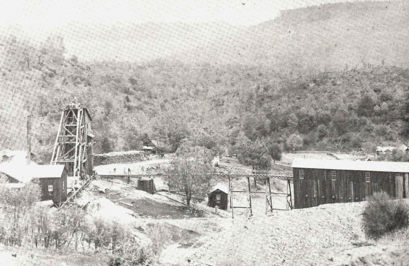
The early 1900s assessment rolls for the mine noted the following improvements on the property: 40-stamp mill, rockbreaker and concentrators, changing room, store house, compressor room, and 3 small houses, a double reel hoist, compressor, 2 motors, 2 transformers, and a small electric light plant, boarding house, stable, and blacksmith shop situated on a portion of Rancho del Rio Estanislaus, bonded from George S. Wright, $30,000 (Calaveras County Assessment Rolls, 1902-1906). Several buildings were depicted in photographs of the mine operations taken during its heyday in the early 1900s, and included the headframe, tramway, mill, boarding house, dwellings, sheds, unidentified structures, and a large stack of cordwood (Calaveras County Historical Society PN531 and 532).
The community was recalled by John Hadaway:
"Sure there was quite a town here once (at Frog Springs). When the Alta Mine was being worked…John Greenhold’s (sic Greenhaulgh) mother (actually the second husband of Mrs. (Katie) Prowse who ran the boarding house) kept a boarding house and there was a school, post office, church and a dance hall. That was when Captain Wright owned the Alta mine. He wouldn’t allow no saloon, but the oldtimers say the dance hall was really something." (Ruppel 1946, in Las Calaveras Vol. XXI:8)
No assessment was noted for the mine in 1907, reflecting the cessation of activities, but the occupation sites in Scorpion Gulch include a stacked rock cellar and possible structure pads (CA-CAL-1862H).
Captain Wright died in 1904, and in 1906, W.O. Manson of San Francisco promoted the sale of Mrs. Wright’s interests in the Grant, including the Alto Mine, for $250,000. In January of the following year the California-Calaveras Mining Company was organized, with David T. Adams as Vice-President, and Mrs. Wright was paid $150,000. Some gold recovery was made in 1910, the last year that any activity was noted. Manson had evidently misrepresented matters regarding the purchase price of the property and the company brought suit against him, litigation that continued for 10 years. Most of the principals had died during this period, and in 1917 Mr. Adams foreclosed on the property and gained possession.
Adams sold the surface rights to 8,137 acres to Samuel and Louis Frankenheimer of Stockton for $72,000, retaining the mineral rights. The mineral rights, as well as the cash received from the transaction, were turned over to a new entity, the Del Rio Mining Company, and the stock was then distributed to the stockholders of the California-Calaveras Mining Company. In 1931 the Frankenheimers sold the property to W.M. Petitfils, who, in 1940, sold out to George S. Gaylord. About 1945 the Gaylord Estate acquired the mineral rights of the Del Rio Mining Company (Las Calaveras No. XXXI, No. 1:9-10).
Ramsey Flat and Gulch, northwest of the Alto Mine, were the locations of other early day mining activities and were apparently named for an early miner or resident of the area, G.R. Ramsey who died in Copperopolis in 1866 (Copperopolis Courier). Ramsey Flat was later taken up for ranching purposes by George Duncan in the early 1860s, sold to G.W. Merritt a few years later, and finally to Thomas Spicer in 1867 (Deed book R:102). According to other accounts, it was also the location of Hadaway Manor, the home of John Hadaway who resided there for many years (Las Calaveras, Vol. XXXI, Number 1).
Another of the early miners in the area was Henry B. Truett, who constructed a ditch from Littlejohn and Clover Creeks (north of present State Route 4) to Scorpion Gulch in 1858. In 1860 Truett was assessed for the water ditch, as well as “one of Howland’s portable quartz mills, with six stamps, situated on Ramsey’s Flat” near his residence (Calaveras County Assessment Rolls 1860).
Ramsey Flat was again worked in the mid-1890s by Oliver Britt and his father-in-law, George Fitch, who obtained an option from George Wright to develop minerals on his Rancho del Rio Estanislao grant. They commenced work at Ramsey Flat, the site of “Hadaway Manor,” but didn’t have much success and soon moved their operations to Scorpion Gulch (Ruppel 1946).
Copper
The 1860s copper boom began with a discovery by H.K. Reed, a penniless miner from O’Byrnes Ferry. This find created another rush to the southwestern portion of Calaveras County, and prospectors overran the area, locating claims on virtually every possible gossan. These flurries of mining activity, both gold and copper, are reflected in the depiction of several mines, ledges, shafts, and claims on period maps (General Land Office 1869, 1870).
A town, first called Grasshopper City, and then Telegraph City, sprang up on Shirley Creek on the Stockton Road. The center of activity, however, was soon transferred to the main Union-Keystone copper lode discovered by Thomas McCarty and William Reed. First known as Copper Cañon, the town that sprang up around the mines was named Copperopolis, and rapidly developed into the second-most important copper district in the United States. The center of town was destroyed in a conflagration in 1867, and, with the cessations of the Civil War and the need for copper for shell casings, was never completely rebuilt. It had, however, for some five or six years, reigned as the most active business and mining community in Calaveras County (Las Calaveras, Vol. XXXI, No. 1:1).
Chrome
Chrome was mined in Calaveras County beginning in the 1890s, with several mines located in the area. Most of these mines were located in the French Creek area and on the Bowie Ranch, where lump ore was mined intermittently since about 1890. The mines on the Bowie Estate operated during 1918 and again in 1942, with about 100 tons of ore mined. (Clark 1962:21; Stone 1991:100).
Asbestos
In 1868, Copperopolis blacksmith Charles Braids discovered asbestos on the west side of Bean Gulch, one of the first chrysotile asbestos deposits to be mined in California. The deposit was first exploited in 1904, when John Albert Voorhees began to develop the property under the auspices of the California Asbestos Company. Work in the Voorhees deposit continued intermittently through 1927, when a company from Oakland leased the property. Over the ensuing years several companies attempted to develop the deposit, but it wasn’t until 1959 when control of the property was obtained by the Jefferson Lake Sulphur Company of New Orleans that work began in earnest. The company began an extensive exploration and development program, constructing a 2500-ton per day mill in 1961. At the height of production, the 500-acre mine milled asbestos in a $5 million dollar plant. Mined by a huge open pit, the asbestos was relatively free milling and the company continued to exploit the deposit until the 1980s, when asbestos was discovered to be carcinogenic and the operation shut down. The open pit is now used as an asbestos disposal site.
By Judith Marvin 2006, for the Tuscany Hills Project
References
Bishop, Frances
n.d. Stanislaus River Ferries. Notes on file, Calaveras County Archives, San Andreas, California.
Brotherton, I.N. “Jack”
1982 Annals of Stanislaus County. Volume I, River Towns and Ferries. Western Tanager Press, Santa Cruz.
Calaveras, County of
Land Claim Books
Homestead Books
Deed Books
Mining Claim Books
Water Right Books
Assessment Rolls
Great Register of Voters Lists
Vital Statistics
Probate Records
Articles of Association
Mechanics Lien Books
Books of Agreements
Minutes of the Court of Sessions
Calaveras Chronicle
var. Calaveras Chronicle, San Andreas. On file, Calaveras County Archives, San Andreas, California.
Calaveras County Historical Society
1986 An Album of the Pioneer Schools of Calaveras County. Calaveras County Historical Society, San Andreas, California.
Clark, William B., and Philip A. Lydon
1962 Mine and Mineral Resources of Calaveras County, California. California Division of Mines and Geology County Report Number 2. California Division of Mines and Geology, San Francisco.
Columbia Gazette
var. Columbia Gazette, various issues.
Crisswell, John
1972 A History of Copperopolis, Calaveras County Historical Society, May 7, 1972. Willard P. Fuller, Jr., Editor. Transcript on file, Calaveras County Historical Society, San Andreas.
Cunningham (Marvin), Judith
1988 Historical Report on the Spicer Ranch and Rancho del Rio Estanislao for the Proposed Copper Cove Effluent Disposal Pond. Prepared for Davis-King & Associates, Standard, California, for submittal to Calaveras County Water District, San Andreas, California.
Davis-King, Shelly, and Judith Marvin
1990 Black Creek Estates and Golf Resort Cultural Resources Reconnaissance. Submitted to Mother Lode Engineering, Altaville, California.
1994 Contextual History of Tuolumne County. Davis-King & Associates, Standard, California and Foothill Resources, Ltd., Murphys, California. Prepared for The County of Tuolumne, Sonora, California.
Dougherty, John W., M.A.
2001 Cultural Resources Inventory of the Proposed Red Mountain Development, Calaveras County, California, Final Report. Prepared for Red Mountain Resorts, LLC, Jamestown. Prepared by PAR Environmental Services, Inc., Sacramento, California.
Elliott, W.W.
1885 Calaveras County Illustrated and Described. W. W. Elliott, Oakland, California. Republished by the Calaveras County Historical Society, Valley Publishers, Fresno, 1976.
Farquhar, Francis P.
1930 Up and Down California in 1860-1864, The Journal of William H. Brewer. Yale University Press, New Haven, Connecticut.
Fuller, Willard P., Jr., Judith Marvin, and Julia G. Costello
1996 Madam Felix’s Gold, The Story of the Madam Felix Mining District, Calaveras County, California. Calaveras County Historical Society and Foothill Resources, Ltd., Calaveras County.
Lewis, L. Helen
1968 A History of Copperopolis. Calaveras County Office of Education, San Andreas.
Gudde, E.G.
1969 California Place Names, 3d ed. University of California Press, Berkeley.
1975 California Gold Camps. Edited by E.K. Gudde. University of California Press, Berkeley.
Hamilton, Fletcher
1915 Mines and Mineral Resources of Amador County, Calaveras County, Tuolumne County. Chapters of the State Mineralogist’s Report, Biennial Period 1913-1914. California State Mining Bureau, San Francisco.
Heckendorn & Wilson
1856 Miners & Business Men’s Directory. Columbia, California. Republished by the Donald I. Segerstrom Memorial Fund, Sonora, California, 1976.
Las Calaveras
var. The Quarterly Bulletin of the Calaveras County Historical Society, San Andreas, California.
Lewis Publishing Company
1892 A Memorial and Biographical History of the Counties of Merced, Stanislaus, Calaveras, Tuolumne and Mariposa, California. The Lewis Publishing Company, Chicago. Facsimile Reproduction published by the McHenry Museum of Art and History, Modesto, California, 1980.
Mace, O’Henry
1991 Between the Rivers, A History of Early Calaveras County. Gold Country Enterprises, Sutter Creek, California, and Cenotto Publications, Jackson, California.
Marvin, Judith
1992 Preliminary Historical Investigations of the Flowers Ranch, Near Copperopolis, Calaveras County, California. Prepared for Archaeological Services, Inc., Stockton, California.
1994 Preliminary Historical Investigations for Three Historic Sites on the Proposed Woodside Partners Project, Near Copperopolis, Calaveras County, California. Prepared for Archaeological Services, Inc., Stockton, California.
1995 Historical Investigations for Three Historic Sites on the Proposed Calaveras Country Club Project (Saddle Creek) Near Copperopolis, Calaveras County, California. Prepared by Foothill Resources, Ltd. for Archaeological Services, Inc., Stockton, California.
2001 Overview History of the Lake Tulloch Reservoir Project Area. Prepared for EDAW Inc., Sacramento, for submittal to Tri-Dam and Pacific Gas & Electric Company, Lake Tulloch Relicensing Project, San Francisco.
2007 Overview History of the Flowers Ranch (Oak Canyon Ranch) Near Copperopolis, Calaveras County, California. Prepared for Jones & Stokes, Sacramento, for submittal to Oak Canyon Ranch, L.L.P., Angels Camp, California.
Ruppel, Margaret Gaylord
1946 El Rancheria del Rio Estanislao, A History. Castle Press, Pasadena, California.
San Andreas Independent. Various issues.
Stewart, Suzanne B. 1991 A Cultural Resources Study for the Bank of San Francisco Copperopolis Project, Calaveras County, California. Prepared for the Bank of San Francisco and Woodside Partners, Archaeological Services, Inc., Stockton, California.
Stone, Rhoda and Charles A. 1991 The Tools are on the Bar. The History of Copperopolis, Calaveras County, California. Rhoda and Charles Stone, Copperopolis, California.
United States Federal Census. 1860 Population Schedule. Calaveras County. Microfilm. 1870 Population Schedule. Calaveras County. Microfilm. 1880 Population Schedule. Calaveras County. Microfilm. 1900 Population Schedule. Calaveras County. Microfilm. 1910 Population Schedule. Calaveras County. Ancestry.com 1920 Population Schedule. Calaveras County. Ancestry.com 1930 Population Schedule. Calaveras County. Ancesstry.com
Wood, Richard Coke. 1955 Calaveras, The Land of Skulls (Calaveras County). The Mother Lode Press, Sonora, California.
Hiatt, Ella McCarty. 1991 Notes on Interview of 1991. On file, Foothill Resources, Ltd., Murphys, California.
Stone, Charles. 1994 Notes on interview of 28 December 1994. On file, Foothill Resources, Ltd., Murphys, California.
1995 Notes on interview of 12 April 1995. On file, Foothill Resources, Ltd., Murphys, California.
Maps
Agostini, J.J. 1904 Official Map of Calaveras County, California. J.J. Agostini, San Andreas, California.
Barton, Eugene H. 1896 Map of the Mother Lode and Principal Quartz Mines in the Counties of Tuolumne and Calaveras. Sonora, California.
Calaveras County Land Patent Maps. n.d On file, Calaveras County Surveyor’s Office, San Andreas, and Foothill Resources, Ltd., Murphys, California.
General Land Office. Township 1 North, Range 12 East Plat Map. 1870 Township 2. North, Range 12, East Plat Map. 1869 Township 1 North, Range 13 East Plat Map
Handy & Wallace. 1864 Map of the Copper Mines of Calaveras County. A. Gensoul, San Francisco. On file, Bancroft Library, University of California, Berkeley.
Pilkington, Thomas. 1854? Map of Calaveras County. On file, Bancroft Library, University of California, Berkeley.
United States Geological Survey. 1916 Copperopolis Quadrangle. Scale 1:625,000. Surveyed 1914. 1939 Copperopolis Quadrangle. Surveyed 1914. 1962 Copperopolis Quadrangle. 7.5 minute series. Photorevised 1987. 1962 Melones Dam Quadrangle. 7.5 minute series. 1962 New Melones Dam Quadrangle. 7.5 minute series. Photorevised 1987.